• 0Shopping Cart
MapCo NZ Ltd - Maori, Pacific Island and New Zealand Maps
  • Home
  • About Us
  • Shop
    • New Zealand
      • New Zealand
      • Regions
      • Marine
      • Topographical
      • Atlases
      • Folded
      • Others
    • Maori
      • Maori Maps
      • Maori Books (Pukapuka)
    • Pacific Islands
      • Pacific Ocean & Islands
      • Others
    • World
      • World Maps
      • Atlases
      • Folded
    • Countries & International
      • Countries
      • Continents
      • Atlases
      • Others
    • Speciality
      • Religious
      • Tectonic Plates
      • Others
    • Charts & Posters
      • Music
      • Human Body
      • Solar & Space
      • Animals
      • Early Learning
      • Others
    • Globes
      • Illuminated
      • Table Globes
      • Inflatable Globes
      • School Globes
  • Testimonials
  • Contact Us
  • 0276410665
  • Search
  • Menu Menu
  • Facebook

Tonga & Fiji

$65.00 Excl G.S.T $74.75 Incl G.S.T

SKU: NZ047 Categories: Others (Pacific), Pacific Ocean & Islands Tags: Fiji, Fiji and Tonga, Islands Map, Pacific Islands, Tonga
  • Description

Description

1000mm x 690mm

Double sided Map

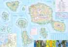
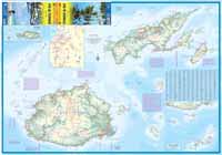
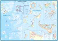
New and updating Fiji map than any map in recent times. We even brought in a Fijian cartographer to ensure that the information would be the best we could make. The many islands of Fiji are a beachcomber’s paradise and as a ‘get-away-from-it-all’ vacation destination, Fiji is hard to beat. With this edition, we have added the island kingdom of Tonga to one side, with Fiji filling the other side and spilling over on to Tonga’s side. Both countries are lovely, but the reality of publishing dictates that we make the best use of our resources, so creating a double-sided cover and combining two compatible neighbouring countries is the only way we can maintain coverage of two very nice parts of the world. The Fiji side includes a very good inset map of Suva and the Tonga side an inset of Nuku’Alofa  and if you didn’t know that these are the two capitals, you do now!

MATT FINISH LAMINATION

ORDER IN ITEM – MAY REQUIRE 1-2 WEEK WAIT

Paper Folded available on request

Related products

  • Islands in American Samoa Marine Chart NZ8685

    $65.00 Original price was: $65.00.$35.00Current price is: $35.00. Excl G.S.T $40.25 Incl G.S.T Sale!
    Add to cart Show Details
  • Treaty_Of_Waitangi

    Treaty of Waitangi Chart

    $55.50 Excl G.S.T $63.83 Incl G.S.T
    Add to cart Show Details
  • NZ019_Papua_New_Guinea

    Papua New Guinea PAPER

    $15.00 Original price was: $15.00.$10.00Current price is: $10.00. Excl G.S.T $11.50 Incl G.S.T Sale!
    Add to cart Show Details
  • Cook Islands & Tahiti

    $65.00 Excl G.S.T $74.75 Incl G.S.T
    Add to cart Show Details

MapCo NZ Maps
MapCo NZ Ltd
New Zealand, Maori, Pacific and International
Maps and Globes

Enquires to [email protected]

Please see our Website www.mapco.co.nz

Leon Smith 0276410665


Contact Us

[email protected]

0276410665

© Copyright - MapCo NZ Ltd
  • Facebook
Islands in American Samoa Marine Chart NZ8685 Cook Islands & Tahiti
Scroll to top